Where is Mount Rinjani?
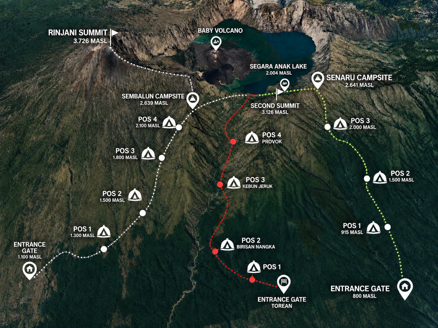
Mount Rinjani is an active volcano on the island of Lombok, in West Nusa Tenggara (NTB), Indonesia, just east of Bali. The mountain and its crater lake are protected inside Gunung Rinjani National Park. The two main trailheads are Sembalun (east) and Senaru (north); the Torean trail is a popular exit on the Senaru side.
Key points and elevations
Approximate, rounded elevations of the main points on the map:
Route breakdown
Sembalun route (east)
The trail starts at Sembalun (about 1,060 m), crosses savanna and passes three rest posts before reaching Plawangan Sembalun, the crater rim camp at about 2,640 m. Day one is roughly 9 km with a climb of about 1,700 m. The summit is reached from here in a pre-dawn climb.
Senaru route (north)
From Senaru the trail enters the national park (about 800 m), climbs through rainforest past three rest posts and reaches Plawangan Senaru, the crater rim at about 2,620 m. The climb is shorter in distance than Sembalun but steeper. From the rim you descend to Segara Anak Lake.
Segara Anak Lake and hot springs
Inside the caldera, Segara Anak (about 2,010 m) is the crater lake where many treks camp. The natural hot springs (Aiq Kalak) are a short walk away, at about 1,960 m, and are a favourite way to rest after the summit.
Torean exit
The Torean trail leaves the lake area through forest and valley to Torean village (about 600 m), usually quieter than the main descent. See our 3D2N Sembalun to Torean package.
Routes and packages on the map
| Package | Route | Price (pp) |
|---|---|---|
| 2D1N Crater Rim Senaru | Senaru → rim → Senaru | USD 119 |
| 2D1N Sembalun Rim & Summit | Sembalun → rim → summit | USD 120 |
| 3D2N Senaru – Sembalun | Senaru → lake → summit → Sembalun | USD 134 |
| 3D2N Sembalun – Senaru | Sembalun → summit → lake → Senaru | USD 135 |
| 3D2N Sembalun to Torean | Sembalun → summit → lake → Torean | USD 136 |
| 4D3N Summit & Lake | Summit and lake at a relaxed pace | USD 145 |
All are sharing group treks (max 8 pax). See the price list for what is included. Elevations and distances are approximate and may vary by source.
Not sure which route? Read Sembalun vs Senaru or the complete Mount Rinjani trekking guide.